Travelogue: J.C. "Sonny" Gilbert WMA and the Legend of the Louisiana Leprechaun

I've gone on some fun hikes over the past few years, but no truly epic ones. What happened to the all day wandering wonders, where I'd drive to a far off destination, put my hiking skills to the test on unknown terrain, then drive around looking for trouble? On my most recent hikes, I've basically driven a shorter distance, run through my hike, and then rushed home to pickup my son from school. However, a few weeks ago, I had an incredible insight, the kind of idea that takes years to formulate: what if my wife picked up my son from school instead? With this kind of genius, near god-tier thinking at my disposal, I asked my wife to pick up my son from school on Tuesday, took the day off of work, and drove all the way up to the mysterious J.C. "Sonny" Gilbert Wildlife Management Area. I'd heard rumor it housed several of the largest waterfalls in the state of Louisiana, and I'd driven through the area a few times before and felt a magical pull, so finally taking the WMA on seemed a no-brainer, ironically, the same expression for when Disney Star Wars has a story group meeting.
"Let's bring back the core three characters from the original trilogy and never put them in the same scene together!"
"Great idea! This is the best "no-brainer" meeting we've had yet!!!"
I left the dystopian binds of East Baton Rouge, and drove through my home parish of Pointe Coupee, passing my brother's produce stand, which you should visit. It's on False River, and vegetables are good for you.
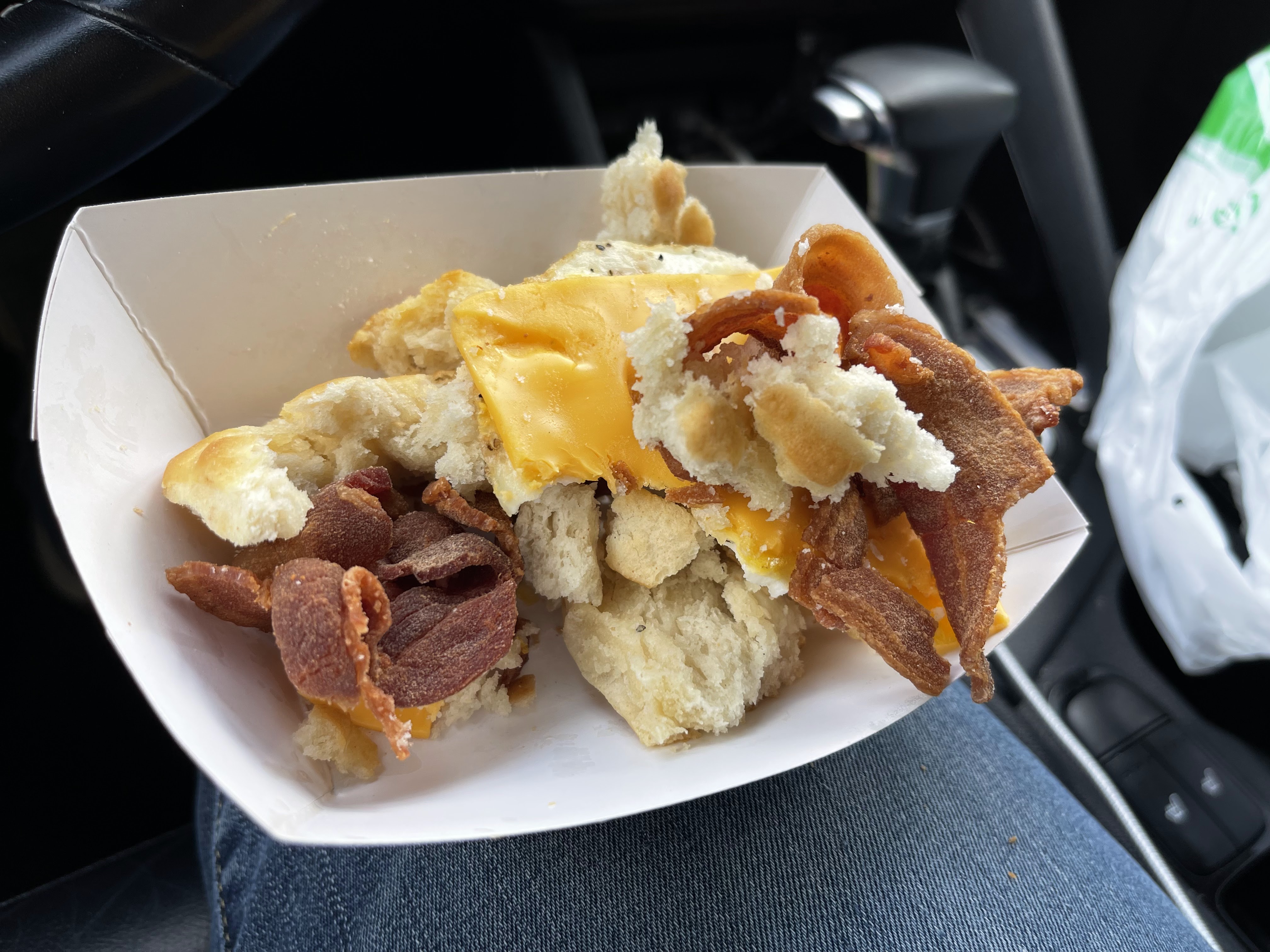
After driving along False River, through New Roads, Louisiana, and across the fabled Morganza Spillway, I reached the town of Batchelor, Louisiana, which is for some reason spelled that way on purpose. On one of the last truly epic hikes I'd taken, I stopped at the Batchelor LA Express/Krispy Krunch Chicken/Hunt Brothers Pizza/Daiquiri Express/US Post Office (for real!) and got a delicious bacon, egg, and cheese biscuit, so I got one of those again, but this time it exploded like my will to live when I watched The Rise of Skywalker.

Unfortunately, a biscuit exploding wasn't the worst thing that happened to me when I was in Batchelor, Louisiana. Indeed, something so horrific, so absurd in the vast extremities of its incomprehensible cosmic terror, I cannot even convey it with more adjectives, but can only post a screenshot of the discussion I had with my cousin, a medical professional, in its aftermath.

Somehow, I survived the incident, passed the Temple of Time (St. Stephen's), and then drove up HWY 15, home of a series of locks, which should be Pointe Coupee Parish's claim to fame, but which are so remote, few people ever see them. Long story short, the storied Mississippi, Red, and Atchafalaya rivers all meet in this one spot, before creating the natural borders of the parish (outside from the southern boundary, which is formed by a sneaky little bayou). The idea is that the immense, retractable concrete locks HOPEFULLY do a better job of keeping the rivers from flooding than me being right does at keeping my wife from correcting me.


From this point on, I enjoyed some good, old-fashioned Louisiana territory, courtesy of the bird's eye view the road affords a driver from the levee, as the road is on a big ass levee, Mississippi river to the right, swamps and crop fields to the left. Again, every lifelong Louisiana resident with a driver's license should drive down this highway at least once, as this topography is our trademark, just like Disney Star Wars' trademark is failure.
After eventually having to turn off of HWY 15 toward my destination, I drove through some good old Northeast Louisiana isolation, until I reached Harrisonburg, Louisiana, though I feel like I just insulted the town of Monterey, which I also drove through, by failing to mention it. Monterey really didn't do anything wrong, and I knew a nice girl from there once, so here's a picture of a gas station I like there, which is named after an animal from Star Wars before it was bought and destroyed by Disney. I guess I'll retire the Disney jokes now.

Harrisonburg, Louisiana, on the banks of the Ouachita, looks like someone airlifted a small Louisiana town into the Great Smoky Mountain foothills in Tennessee. You're just driving through the normal swampy, flat Louisiana terrain, then you round a corner, and there's a 200-foot-tall hill full of tombstones in your face. The first time I ever saw it, I thought I'd eaten a bad bacon, egg, and cheese biscuit and was hallucinating. I actually had to slightly pass my turnoff to drive into Harrisonburg this day, but I wanted to see it, plus I wanted to visit this old timey food place called...Old Towne Boutique and Deli I'd noticed in Harrisonburg before, as it is essentially the only place to eat in Harrisonburg, a town of under 300 that Wikipedia says has experienced such a large demographic decline, it runs the risk of becoming a ghost town, even if it was once considered a possible location for the state capital, and it's the Catahoula Parish seat, with a courthouse the size of a Cat Island cypress, my apologies if you don't speak Louisianaese.

Unfortunately, Wikipedia's presumptions were proven correct, as Old Towne has shutdown, a rhyme that is way too satisfying to type, considering its implications. I knew there were no food places ANYWHERE near these geographic coordinates, so I was happy to see there was at least something else open in its place, though the separate signage of "The Deli" and "DownTown Nutrition" confused me. Turns out these are two separate businesses in the same room, perhaps run by a mother/daughter duo, I'm not sure...if they aren't mother/daughter, they're the same age as a mother/daughter. My additional plan was to just get food from The Deli, so I ordered a cheeseburger and fries--the menu is your general American food with a few Louisiana touches, like boudin balls. However, as I sat on a bench to wait for my food (there is no dining area), a man came in workman's overalls, I'll just call him "T-Boy," and started talking to the young woman behind the counter of the DownTown Nutrition side. At this point, I looked at the DTN wall menu, and saw there were enough choices to make an indecisive person's head explode worse than if you got them a voice assistant whose only programmed response is "are you sure?"


"What you getting today, T-Boy?" the young woman asked.
"I guess I'll take the Southern Belle. Could you please not write it on the cup this time? The boys'll make fun of me."
She went off to make T-Boy's Southern Belle and I asked him what the heck all these drinks on the menu were.
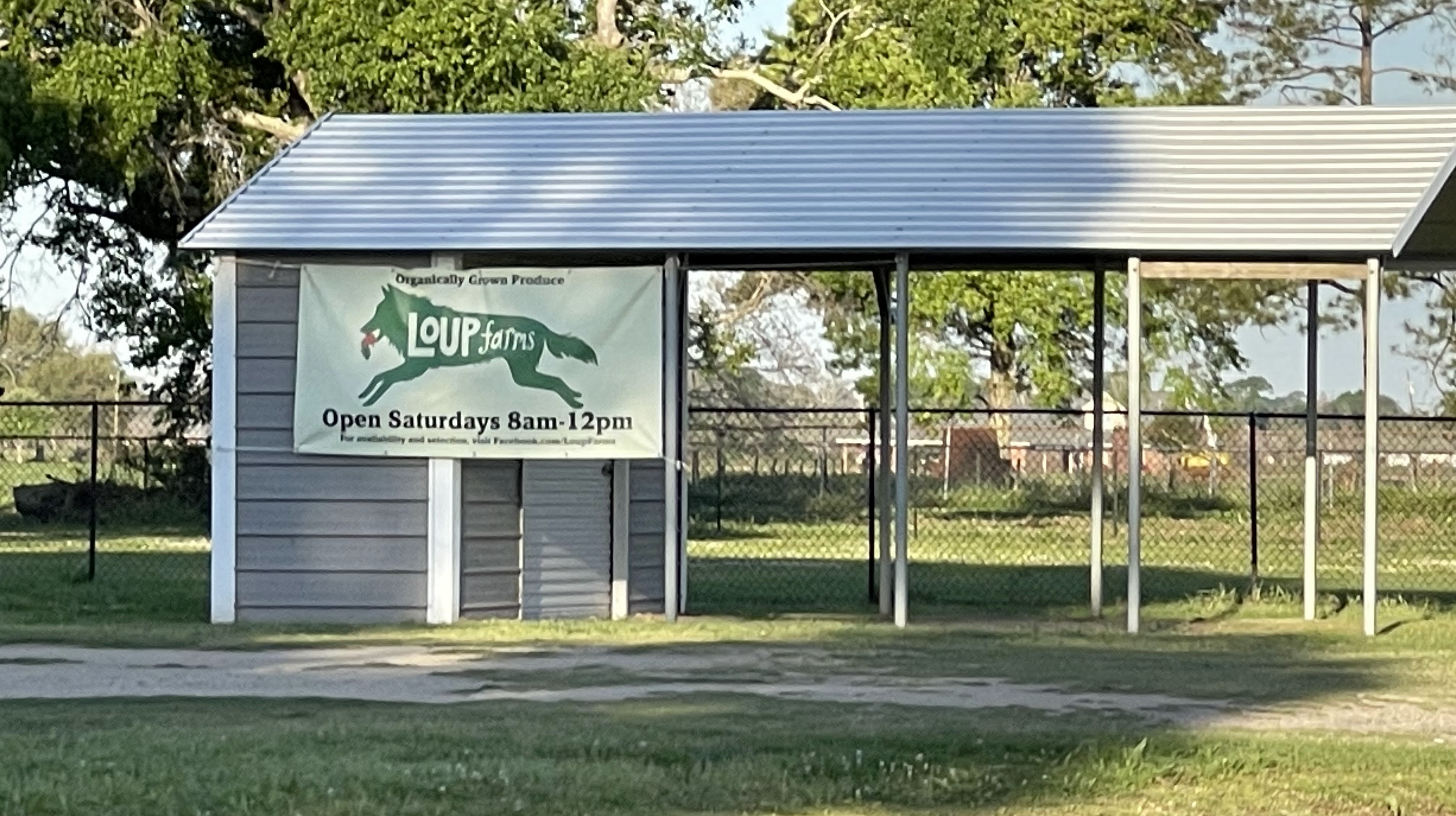
"That place's stuff across the way tastes like a vitamin, but her teas here are real good," he said, completely blowing my mind that in a town of under 300 people, in the middle of God's nowhere, there might be two competing specialty tea businesses. Whatever the case, DownTown Nutrition makes a large variety of fruit-infused iced teas. Since T-Boy spoke so highly of them, and the girl running the counter seemed like an absolute sweetheart--and I am going to assume every single person who lives in Harrisonburg is an absolute sweetheart, for I felt that the entire town was earning my business--I bought a tea. Since it was three days before St. Patrick's Day, I decided to honor my Irish forebears by ordering a Leprechaun. Then I took my food to my car to eat and get back on the road.


The burger and fries were fine, may have been made from frozen stuff, but they tasted well enough and gave me the calories I'd need to burn during my hike. However, the Leprechaun, infused with pineapple and kiwi, was a revelation, so incredibly delicious and refreshing that I turned off my car, ran right back into DownTown Nutrition, held up my drink and yelled "Thank you, this is great!" to which the girl at the counter yelled back, "Thank you so much! It's nutritious too!" and it must have been because I not only felt great for the rest of the day, but didn't get Diphtheria from the Batchelor LA Express bathroom. I ate enough of my double-cheeseburger to turn it into a one hander, thus rendering driving at least as safe as regularly eating double-cheeseburgers, and then backtracked a few hundred yards to the turnoff toward my destination, as Harrisonburg is just past the southeastern edge of the J.C. "Sonny" Gilbert WMA. I crossed the Ouachita, noticed a heavily wooded and hilled area to my left, and began to look for the WMA entrance. I soon found out why the Wildlife and Fisheries agent who recently helped me get a WMA permit finished our conversation with the phrase "good luck."


Outside of a small marker notifying the visitor to turn left, there is little signage signifying you are entering the Gilbert WMA. I was a little startled to find that the road leading up and away from the highway was nothing more than lightly graveled dirt, full of holes and dips. I immediately said, "Damn, I wish I had my Jeep," and now I realize that all of these travelogues have an ongoing subplot about my vehicles. In the last hiking travelogue I posted, I mentioned that I traded in my beloved 2017 Jeep Renegade Altitude for a 2021 Jeep Renegade Latitude, which I took on that hike. I was immediately horrified to find, however, that my new 2021 Jeep was merely a pale shadow of my last one. It had far less features, the stereo was like a flat butt in yoga pants, and it even drove differently, and far less fun. My 2017 Jeep spoke to me when I first sat in it six years ago, but this 2021 model was dumb in every sense of the word, and I quite angrily felt like the dealership had hornswoggled me. I then went on an intense quest that only someone with my unique combination of OCD, stubbornness, and, my wife would say, "autistic qualities" would embark upon, eventually trading the 2021 Jeep for a lightly used 2019 Kia Niro, which gets 50 miles to the gallon, and is quite spacious, which is, coincidentally, what everyone says about your mom.

I have to give props to my Niro, as I put it through its paces, and it performed magnificently. It may have been covered in sand and red mud by the end of the day, but it never got stuck. I drove my Niro up the twisting, rising dirt road for a while before coming to a small, self check-in station that contained absolutely zero maps, or instructions on how to get to anything, outside of a sign reminding visitors to be "Bearwise," which is weird, because I didn't think bears were that smart. All I had to go on were the wildlife agent I spoke to's cryptic instructions: "Rocks falls is located on south end (~1 mile), St. Mary’s (~1 mile) & Big Creek (~ 7 miles) are located on North end" and the cryptic online map, which makes a lot more sense now that I have been through the entire WMA and am not looking at it on my tiny cell phone screen. As such, after the check-in station, I turned right on a whim and drove for quite a bit until I saw, to my great relief, a trailhead.


I parked in an off-road spot across from the trailhead, and four hours after I got in my car that morning, finally got out to go hiking. I'd planned this hike out a while ago, but changed the day last minute because it looked to be so nice this Tuesday, and it was indeed about as nice as a sober Louisiana day can be. There's a reason Louisiana has drive-through daiquiri stands and essentially no rules against walking around with booze in many areas--most people can't come up with another way to cope with constant 100 degree heat/100 percent humidity for eight months a year, let alone the crushing poverty, failing school systems, and endless, list-topping violence. However, on this day, the temperatures peaked at 50, the humidity was low, the sun was mild, my WMA access permit only cost $5, I wasn't in school, and the only violence I had to fear was from a marauding bear and thanks to the sign near the entrance, I was BEARWISE. I hopped right onto that hiking trail and marched along until I heard the sound of rushing, crashing water.


Thankfully, that sound wasn't my bladder bursting from all the fruit-infused tea, but a massive (for Louisiana) waterfall. In fact, this waterfall, Rock Falls, is the tallest waterfall in Louisiana. Apparently, the final plunge is 17-feet, so I guess the entire thing is about 30-feet tall, or at least it feels that way to me. If you want to see Rock Falls, you've got to visit one of the most remote areas in the state, drive down an unmarked, unpaved road, hike an admittedly pretty steep and wild trail, and also be bearwise. As I attempted to reach the base of the waterfall, to which there is no trail, I realized something: I need hiking shoes. Over the last few years, my everyday casual shoes have gradually become my marathon running shoes once I've put 500 miles on them and they're no longer any good for running. Something I realized when trying to climb down slippery, just barely over 90 degree ledges with my current shoes is that they have absolutely no grips and are as slick as T-Boy's homemade slip 'n slide after he's poured Crisco all over it. Falling down a ravine in the middle of nowhere with no cellphone signal at age 41 with a wife and teenager at home is now a less inviting prospect than at essentially any other point in my life, so I stuck to the main trail, which at least does take the hiker over the top of the waterfall. Here is a video of that.
I traversed the rest of the Rock Falls trail, a rough 1.5 miles of steep inclines and fairly grown over, but well-marked by spray paint on trees path. I found a few more pretty little waterfalls and finished the trail, hungry for more. Unfortunately, after driving for a while on the rough path, which again, my Niro handled masterfully, I had to stop to move a tree out of the highway (easily done with Leprechaun power), then got back to driving and reached the end of the road, or at least a point in the road that featured barbed wire and NO TRESPASSING signs.

I was quite confused, as I was told there were three hiking paths at old Sonny's WMA. Looking at the map again, it kind of looked like the south and north sides of the WMA weren't connected, unless you were a bird, in which case, everything is connected. At this point, I felt like I'd ordered a Big Mac and the drive through attendant, Lil T-Boy, had just handed me nothing but a bun slathered in secret sauce. I signed out of the WMA (you've got to drop a form in the entrance box to tell them you're leaving, as well as notate your activities there), and hit the highway again, dejected. I aimlessly drove around the Sicily Island area for awhile, blasting heavy metal into the empty Central Louisiana air, until I found a highway that seemed to run along the north side of the WMA's borders, remembering the wildlife agent's cryptic note. Sure enough, I found another, more northerly entrance to the W.M.A., and I am resisting making a joke about your mom harder than I ever have before, so here are some other pictures from the Rock Falls trail before I move on.


After checking in at the north-side self-serve box, which sounds like soft serve and now I want ice cream, I yet again blindly drove down a perilous, unpaved, hilly road, seeing no one, which is generally the amount of people you see when you go hiking in Louisiana. Eventually, I came upon another trailhead, this one labeled ST. MARY'S FALLS. And thus, I hiked again.

I guess because of the WMA's remoteness, because of how seldom it is visited by hikers, the managers must figure "If you come here to hike, you must really be into hiking" because the St. Mary's Falls trail features, at least for Louisiana, incredibly steep inclines, areas of heavy brush, multiple creek crosses that require the hiker to climb up embankments, and general tomfoolery. I greatly enjoyed it, but I definitely wouldn't take a kid or an elderly person to this trail unless they were fit and experienced. Either 1/4 of the way in, or 3/4 of the way into the hike, depending on which direction the hiker takes when the path splits into a large circle, a wooden cross appears. It is at this point the hiker reaches the spirit realm.
Rock Falls might be taller, but St. Mary's two waterfalls create a zenned out biome I've never experienced before in my home state. The path down was steep, but this time, I could not resist the waterfalls' siren song, and I slid down to the creek bed like T-Boy after a waterfall's worth of moonshine. Either of these two waterfalls would be beautiful on their own, but two? The left fall features an incredibly thick rock shelf that seems transported from some Sonoran desert oasis directly into a Louisiana sub-tropical forest.


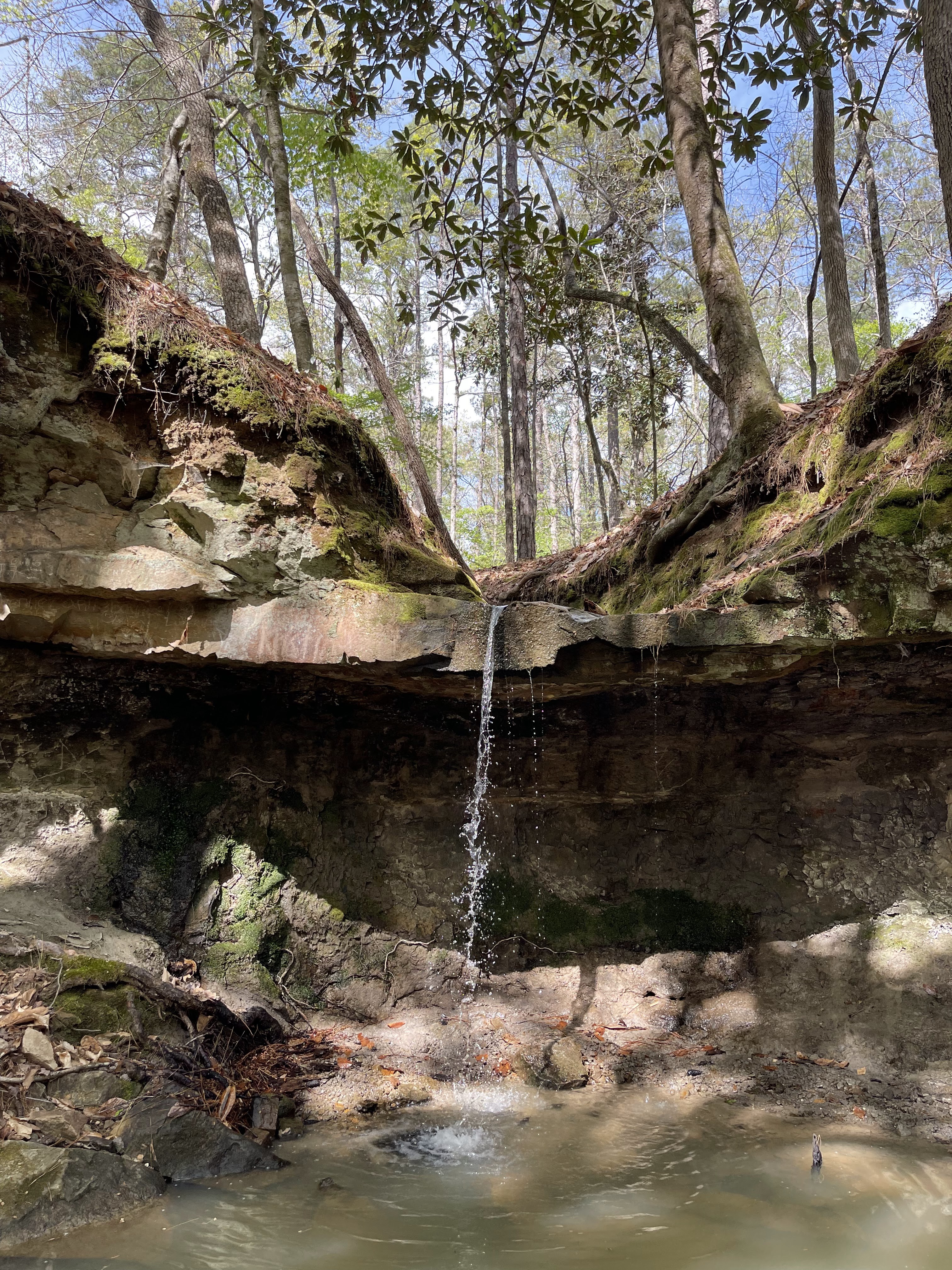


The left waterfall is the most fun, as the pool below is wide and shallow and feels like its own microclimate, with water shimmering on cliff walls, moss, lichen, and algae blooming below, and leaves waving in the breeze and shifting sunlight above. If there's a more beautiful spot in the state, I haven't seen it. The right waterfall is no slouch, and while I couldn't get right underneath it, due to its more narrow, deeper pool, I was still able to get quite close. It features a beautiful cascade, gently falling over a mineral-stained rock face.


After basking in this majestic mirage for an hour, I realized that my hiking adventures for the day had peaked, and that I wasn't going to top this extended moment. I climbed back up to the path with the intention of finishing the trail and getting back to my Kia, but mamma mia, the trail had some plans for me. The path winded back and forth through the creek like a moonshined T-Boy at a DWI checkpoint, disappearing up steep hillsides and brush, and reaching a near unforgivable moment pictured below, where the only point of egress past a creek crossing was burying my hands in poison ivy, after which I repeatedly washed my hands in the cold creek water. Thankfully, this warded off the dreaded poison ivy rash, like Disney's Star Wars wards off financial profit.

I made it back to my car and remembered there was still one trail to go. However, it was already 4:00 pm, I was presumably four hours from home, and the final trail, Big Creek, is apparently seven miles long, and purports to feature the roughest terrain of any of the three trails. With the age (provable with a certificate) and wisdom (not as provable with a certificate) I've accrued over the past 41 years, I decided to call it a hiking day, with the concession that I had to at least FIND the Big Creek trailhead before I left the WMA, so that I can hopefully return to complete it some time later this year. Thankfully, find it I did, as I now not only understand the cryptic directions I was given, but felt I could now give much better ones: "If you want to hike the Rock Falls trail, enter on HWY 8, and then keep right on the dirt road. If you want to hike St. Mary's Falls or Big Creek, enter on HWY 915 and stay right. Make sure you don't show up in a Dodge Dart. The road's a little rough. Good luck." I wonder if the minimalistic instructions and signage around the WMA are due to the fact that almost no one ever goes there, though as I said before, it's not like I see anyone when I hike in more well-tended, less remote Louisiana hiking spots.

After finding the entrance to Big Creek, pointing at it, and threatening it with the phrase "Next time," I did a U-turn in the middle of the forest and no one heard. Then I drove back to HWY 915 and decided to drive toward Natchez, to satiate the immense debt of hunger I'd accrued, and the only cuisine that rhymes with accrue is barbeque. I was still high on Leprechaun power and the joys of being one with nature and all that hippie stuff, so I had a marvelous, metal-backed drive through the wild to Ferriday, then Vidalia, then across the Mississippi to Natchez. For some reason, I decided to veer off the highway to the levee road along Lake Concordia near Ferriday, until the lake ends, and a big Mississippi River bend starts, at which point I looked to my left and saw a bunch of hunting and fishing camps sitting out in the water on stilts. I took some pictures, but I had a bunch of pissed off pickup trucks tailgating me, so they're not very good pictures, but I checked a map later, and this stretch is called "Old River Boat Camp Road," which is a good name, since you can only get to these camps by boat.


After this strange side adventure, I called my wife to make sure she picked up our son, not because I don't trust her, but because I don't trust anything. I then got back to the main highway and reached Vidalia, famous for having a great view of Natchez, and sharing a name with a more famous town from Georgia that farms onions, but hey, Vidalia, I love you anyway. I had a spiritual experience under the Natchez bridge in Vidalia in late 2008, and since that whole area is now a nice little park, I decided to make a brief visit because how often are you in Vidalia. That came out rhetorically. I meant, "How often am I in Vidalia?" Not often. It's beautiful.

I then performed the only action possible for someone in my position, and that was to visit the Pig Out Inn and pig out. I ordered some ribs and some brisket and some baked beans and some macaroni and I ate everything but the bones, and even some of the bones, and then I just sat there and smelled my empty plate, while the blues poured out of an unseen speaker, then told my green-haired, half-head-shaved, ear plugs the size of half-dollars busgirl, "Thank you, that was incredible" and received a sweet, birdsong-pitched, country-fried, "Thank you, have a good one," in response.


At this point, I figured there was only one thing left to do. I'd noticed over several brief Natchez visits that there was some type of nice park at the top of the bluffs above the river. Natchez has bluffs, by the way. I found that I could walk from Pig Out Inn to that park, all while burning almost 1/100 of the calories I'd just consumed. Natchez' population might be falling as precipitously as Harrisonburg's is, but on that day, it was a nice place.


And with that, I decided to drive home, back to 9-hours-a-day in an office, spreadsheets, bills, and sirens. But what a drive it was.


Comments